Search
-
Join 2,510 other subscribers
Book TA as a Speaker
")
Expedition Photo Galleries

-
TA’s Recent Blog Posts
Explore TA's Website
Aconcagua All around the Circle Ama Dablam Aoraki/Mount Cook Buddhism Canoe Canyons Denali Elbrus Elbrus-06 Everest-007 Everest 3.0 Everest 2010 Find Your Fit Fire&Ice17 Great Big Walk Great Himalaya Trail Gunnbjørn Fjeld Kanairiktok River Kerry Way Kilimanjaro Labrador Life Loca-venturing Logan Lungta Livyers Memorial University Mera & Island Mission 5959 Mountaineering Newfoundland Ojos Orizaba Paddle 2 Peaks Paddling North Photo Gallery Photography Pretty Big Walk Pumori River With Two Names Sea Kayak Ski Tajumulco Tibet Bike Toubkal Video Vinson Visual Soliloquy Volcanopalooza WaterTA’s Latest Publication

TA’s Facebook Page
Blog Tags
- 2010
- 2011
- 2012
- 2013
- 2014
- 2015
- 2016
- 2017
- 2018
- 2019
- 2024
- Adlatok
- adventure
- All around the Circle
- Antarctica
- Athabasca River
- Atlas Mountains
- Buddhism
- Canada
- canoe
- Churchill River
- climb
- El Salvador
- Everest
- Everest 3.0. school curriculum
- Everest 2010
- expedition
- Find Your Fit
- Fogo
- Folklore
- GHT
- Go for Greenland
- Great Himalaya Trail
- Guatemala
- I's the B'y
- Iceland
- Kanairiktok River
- Karuna
- Kilimanjaro
- Labrador
- Lojong Slogans
- Lungta
- Mackenzie River
- Mission 5959
- Mista Shipu
- Moreton's Harbour
- Morocco
- Mountains of Morocco
- Nature
- Nepal
- Newfoundland
- Newfoundland and Labrador
- Notakwanon River
- Nunatsiavut
- peak
- photography
- Post by Voice
- prayer flags
- Quotes
- Royal Canadian Geographic Society
- School Curriculum
- sea kayak
- Seven Summits
- Slave River
- train
- training
- Travel
- trek
- Twillingate
- Ugtoklok
- Vinson
- volcanoes
- What's TA Climbing Next?
- WOKies
- Yukon
Tag Archives: Churchill River
Churchill River Camp Seven SPOT Report
TA Latitude:53.25389 Longitude:-60.78052 GPS location Date/Time:07/27/2012 10:47:04 NDT Message:TA’s location on her Churchill River (Labrador) Canoe Expedition. Click the link below to see where I am located. http://fms.ws/8py2p/53.25389N/60.78052W If the above link does not work, try this link:
Churchill River Camp Seven SPOT Report
TA Latitude:53.19131 Longitude:-60.92038 GPS location Date/Time:07/26/2012 19:23:21 NDT Message:TA’s location on her Churchill River (Labrador) Canoe Expedition. Click the link below to see where I am located. http://fms.ws/8pLBV/53.19131N/60.92038W If the above link does not work, try this link: TA You … Continue reading
Churchill River Camp Six SPOT Report
TA Latitude:52.97775 Longitude:-61.48331 GPS location Date/Time:07/25/2012 16:47:39 NDT Message:TA’s location on her Churchill River (Labrador) Canoe Expedition. Click the link below to see where I am located. http://fms.ws/8o2IJ/52.97775N/61.48331W If the above link does not work, try this link: TA You … Continue reading
Churchill River Camp Five SPOT Report
TA Latitude:52.89374 Longitude:-61.86511 GPS location Date/Time:07/24/2012 21:01:09 NDT Message:TA’s location on her Churchill River (Labrador) Canoe Expedition. Click the link below to see where I am located. http://fms.ws/8nFgC/52.89374N/61.86511W If the above link does not work, try this link: TA You … Continue reading
Churchill River Camp Four SPOT Report
TA Latitude:53.06435 Longitude:-62.20901 GPS location Date/Time:07/23/2012 17:39:33 NDT Message:TA’s location on her Churchill River (Labrador) Canoe Expedition. Click the link below to see where I am located. http://fms.ws/8m6AV/53.06435N/62.20901W If the above link does not work, try this link: TA You … Continue reading
Churchill River Camp Three SPOT Report
TA Latitude:53.15319 Longitude:-62.59439 GPS location Date/Time:07/22/2012 19:35:28 NDT Message:TA’s location on her Churchill River (Labrador) Canoe Expedition. Click the link below to see where I am located. http://fms.ws/8lFeR/53.15319N/62.59439W If the above link does not work, try this link: TA You … Continue reading
Churchill River Camp Two SPOT Report
TA Latitude:53.20555 Longitude:-63.17749 GPS location Date/Time:07/21/2012 16:43:00 NDT Message:TA’s location on her Churchill River (Labrador) Canoe Expedition. Click the link below to see where I am located. http://fms.ws/8k66P/53.20555N/63.17749W If the above link does not work, try this link: TA You … Continue reading
Churchill River Camp One SPOT Report
TA Latitude:53.42689 Longitude:-63.63092 GPS location Date/Time:07/20/2012 16:59:40 NDT Message:TA’s location on her Churchill River (Labrador) Canoe Expedition. Click the link below to see where I am located. http://fms.ws/8j6Yc/53.42689N/63.63092W If the above link does not work, try this link:
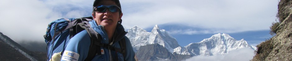
In the Big Land
After a two hour ferry ride, about 100 km of pavement and 500 km of gravel highway, we arrived in Goose Bay, Labrador this evening. As the backseat rider I read seven magazines and my entire 321 page book so … Continue reading
Almost to Labrador
The expedition team had a good day of driving. 12 hours of driving have landed us in St. Barbe with a ferry across the Labrador Straits in the morning. I’m looking forward to driving the new road all the way … Continue reading
