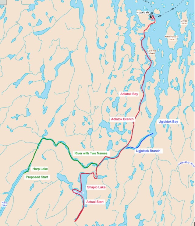
Our Route Overview Map
Eight years after completing our epic descent of the Notakwanon River, four of us (Mark Dykeman, Darren McDonald, Marian Wissink and I) returned to Labrador for two weeks to tackle another river, Mark and Darren in sea kayaks, Marion and me in our canoe. Depending on which map you consult, which trip report you uncover, which river monitoring station you check, and which website you look at, this summer’s river has two names.
On the provincial road map, the upper part of the river is called the Adlatok River and the branch that leads to Ugjoktok Bay is the Ugjoktok River. On Canadian topographical maps, the upper part of the river is called the Ugjoktok River and the branch leading to Adlatok Bay is called the Adlatok River.
The Overview Map of Our Route
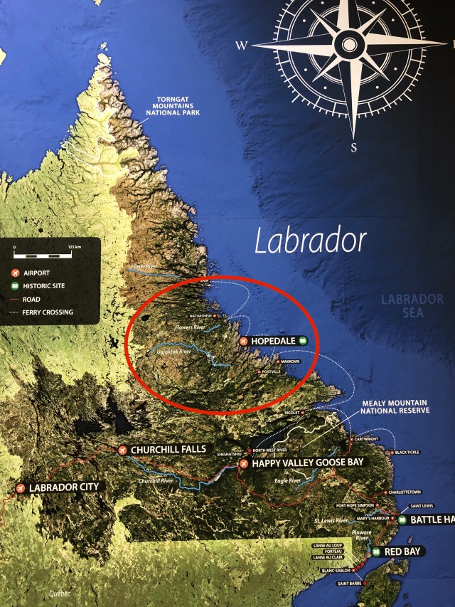
Not wanting to take sides, and needing to do much more research about the river’s names, place, and the folks who have lived by it and travelled it, we decided to use both names. In the lead-up to the expedition, I enjoyed looking through archival documents and noticed several different spellings of the river’s names as well. From an article written by Jamie Jackman of the Labrador Institute, I learned that Innu hunters and their families used parts of the 258-kilometre-long waterway as a travel route from the country’s interior to the trading post at Hopedale. Jamie has a family connection to the river and community of Adlatok. He mentions that those who visit “quickly fall in love with Adlatok Bay, evident in the way many earlier pioneers and leaders discuss its natural beauty in Labradorian literature.”
I contacted Jamie and asked him if he could tell me more about the names of the two rivers. He replied with the following:
“According to my father, Ujutok is the main river and empties into a Ujutok Bay just south of Adlatok Bay. The Adlatok River flows out of the Ujutok River. However, I’ve also heard the main river referred to as Adlatok right from the height of land and that it empties into Ujutok and Adlatok…the Adlatok branch of the river being referred to as the Adlatok River. This is not surprising however as maps around here are not always accurate in regards to place names – more work needs to be done on this before the real place names are lost forever, in my opinion.”
Adlatok is an anglicized version of the word “Allatok” or “Allatuk” or “Allaktuk” – I’ve seen it written each way – which, from my understanding, translates roughly to “Place of the Innu” or “Where there are Innu” – Allak being the Inuit word for “Innu.” The Innu would travel along this river from inland and come out at Adlatok Bay on their way to trade furs. The Bay was frequently visited by Innu travellers, who would stop to visit the Inuit settlers who lived there later on, my grandparents. As for Ujutok, according to my cousin Brian, it derives from the Inuit word for seal, ujuk, so Ujutok or “Ujuktuk” means roughly “Where there are seal.””

I continued searching the MUN Library and Digital Archives and found the above edition of the Newfoundland Quarterly from Fall 1991/Winter 1992. The cover features a watercolour of the Northern lights above the Adlatok River. The artist is not named, but the work captures the beauty sky, land, and water. I also learned that the late President George H.W. Bush fished the Adlatok River, as have folks from all over the world. The largest salmon ever caught in this province was landed on the Adlatok River. A 1994 Toronto Star article said that President Bush had fallen in love with Labrador and was quoted as saying, “I left about a year ago, almost to this day, and for the in-between 365 days we’ve been thinking of nothing except coming back up here to the Adlatok.”
At this point, you are likely terribly confused about the river and its names, so please take another look at the overview map above where the red line marks the route we paddled and the green line marked our planned route.
The Beginning
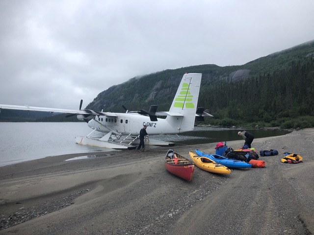
You’ll notice that I said, “Planned route.” Given low-lying fog on the morning we flew out of Goose Bay, we were unable to land on Harp Lake. Harp Lake is 50 kilometres long, 1.5 kilometres wide, and has 600-metre-high canyon-like sides. With little to no visibility at the top elevations of the canyon, it was impossible to land safely. When the floatplane turned south to return to Goose Bay, we sank into a collective depression. Keith, the pilot, asked if we wanted to be dropped in Snegamook Lake. I climbed over the seats to go talk to Mark and Darren who were seated in the back of the plane. Marian and I had paddled the Kanairiktok River in 2015 so were familiar with it but none of us had paper maps of the area. A quick consult yielded a negative decision on that option and I communicated that to the co-pilot.
Soon thereafter, the plane began a rapid descent and landed on Shapio Lake. We knew from our research prior to the trip that Shapio Lake drained into the River with Two Names. We collectively rejoiced at not having to return to Goose Bay. The pilots confirmed that we were okay with this “second prize” drop-off location and soon sped away, leaving us in the deep silence of Labrador. You can see Shapio Lake on the map above. We were deposited on a gorgeous beach at the southern end where the lake narrows.
As our new (and very unexpected) drop-off location had lopped about 80 kilometres off of our route, we had time to take the day to get used to the new plan. We got camp organized and spent the afternoon hiking to get a view of our surroundings. The sky turned blue, the fog lifted, and we wished we’d been able to fly out of Goose Bay later in the day. We agreed to sulk about it for the remainder of the day and then let it go and have a fine adventure.

Day Two dawned fine and still. Harp Lake was forgotten. We spent our first day exploring the southern end of Shapio Lake. The mirror surface of the lake produced a landscape-size kaleidoscope of rock and sky. On Day Three we paddled towards the northern end of Shapio, heading into its into the western arm for lunch. Late in the afternoon, with 15 km of SW fetch, the lake challenged Marian and me (paddling the canoe) with a small surf landing at our campsite.

The next morning, the black flies were swarming, and we became breakfast as we packed our boats to the first portage. From the maps, we were pretty sure the exit of Shapio Lake would be protected by waterfalls. We were correct and set about finding the best way to get ourselves, our boats, and our gear past these frothing obstacles. We went scouting and first found a dry river channel that could work as a portage, but then Marian found a portage trail that made the carrying much less tricky in the footing department. Darren spotted a line through the two waterfalls he might have been able to run if he had had an empty creek boat rather than his Hammer hybrid kayak filled with expedition gear.

After paddling five kilometres along what we decided to call the Shapio River, we pulled off to river left when another waterfall blocked our progress. Indeed, four waterfalls blocked our progress to the River with Two Names, so we had some decisions to make about our portage route – do one long carry around all the falls or find a way back to the river after the first one? A deeply worn portage trail led us to a stunning campsite carpeted in caribou lichen. We decided to stop for the day and think about it.
The next morning, after studying the maps and taking a jaunt along the portage trail, the most expedient plan seemed to be to make the long portage around all of the waterfalls. The carry distance was 1.6 kilometres to a spot where we could stash the boats prior to a steep drop to the launch. We knew we couldn’t do it all one day, so we divided our gear into what we would transport the first day and what we would need for a second night in our stunning campsite.
The first big load down the portage trail was indeed a pull for our kayakers. Darren and Mark – who had declared one rule before the trip began, “I don’t paddle uphill and I don’t portage”- loaded up their kayaks and began to pull. In the process, they did a thorough study of the coefficient of friction between plastic kayaks and caribou lichen (technical article for submission to the appropriate journals is in the works). The day was scorching hot, the bugs ravenous, and I was glad Marian and I were carrying the canoe for the shade it provided. We stopped often to rest, swat flies, and curse the original fog that had led us to a route allowing this moment of, uh, self-development. We carried the last load the next morning, after getting to experience our campsite in the driving rain.
Reunited with our gear, we now had to sort out getting it down to the river’s edge. Mark tied a rope to his kayak, kicked it over the lip, and held on for the steep 30-metre descent. Darren, Marian and I followed in a similar fashion. The woods were soaked with the previous night’s rain and by the time we reached the bottom, so were we. After a few more schleps up and down, in tight quarters with ferocious flies, we stuffed everything back into the boats and paddled briefly upstream. We quickly turned to go with the current and found an island on which to get warm and fueled. Five days in, we took our first paddle strokes on the River with Two Names.

Map consultation
Map consultation
At this point, the river was exchanging its rocky shores for black spruce-covered sandy banks. We enjoyed the push from the current and floated to watch the scenery go by. Surveying the banks, our new home didn’t seem all that hospitable to camping; it took several tries to find a suitable spot amid sand bars that would force us to wade to shore, crumbling sandbanks, and our wish for a breeze to ward off the flies. We settled for river left on a sandy beach, the first that let us get all the way in without pulling the boats through the water. Starting Day Six, we were one kilometre up from where the river split into two, the northern branch flowing to Adlatok Bay and the southern to Ugjogtok Bay. Before leaving home, we’d decided to paddle the Adlatok branch, so at the fork, we turned left to paddle on the River with One Name: the Adlatok.
The River with One Name
About seven kilometres down the Adlatok, we stopped to scout the only rapid of the trip we would all paddle as a group. We followed Darren’s line down the rapid and tried our best not to run over him. It was the perfect rapid to run – big enough to get us excited, but small enough that the waves only filled one-third of our canoe. At the bottom, we stopped to bail our canoe while Darren played in the rapid. By then we’d worked up an appetite and we enjoyed lunch on another sandy beach.

The afternoon’s paddle took us to the mouth of the canyon that empties the Adlatok into the sea. From our map study before the trip, Marian and I had noted the likely potential of a portage around the canyon and last rapids that started about half a kilometre downstream from the canyon. This research was confirmed when Mark spoke to one of the owners of Camp Adlatok while we were in Goose Bay. He warned Mark, “You don’t want to be in that canyon.” The portage headed slightly uphill from a grassy nook on river right. Mark set out scouting along it but quickly returned saying his way was blocked by water. Our (by now) experienced tow team went into action and pulled Mark’s kayak up to the small pond. He jumped in, paddled across, and confirmed the portage trail continued. When he returned, it took all four of us to drag our loaded canoe the 100 metres to the pond. It reminded me of pulling tires up Signal Hill. Once on the far side, we took a light load and scouted further up. About a kilometre uphill, our way was again blocked by another small pond. We dropped our loads and climbed a nearby hill to see the view and confirm that we could proceed after the pond. We decided to bring the rest of the gear and boats up to this point.
By the time we’d accomplished this, it was time to make camp amid the worst bugs of the trip. I had started to collect firewood when Mark noticed that my normally-white jacket was black, teeming with flies trying to find a way in. He suggested that I forego cooking outside, taking shelter away from the torment in our bug house, and cooking dinner over the MSR stove instead of a fire.
We woke to misty rain on the morning of Day Eight. We packed and scouted the rest of the portage. It seemed to be a route that folks from Hopedale use in winter to bypass the rapids and waterfalls when travelling by snowmobile; this would explain why the portage crossed two small ponds and a bog. At Adlatok Bay, the wind was blowing hard, waves crashed against the shore, and the temperature was dropping. By the time we finished the portage and reloaded the boats, we were cold and damp. We needed to paddle around a small point, across the mouth of the Adlatok River, and then around another point to reach Camp Adlatok. With the wind, the paddling was challenging in the canoe, but we made it in good style.

We made camp out of the wind and checked out the river from a nearby high vantage point. The rapids below the canyon section were likely a lovely run. There was some discussion of hauling our boats up the next day to make a go at them. But, waking to a temperature of just two degrees, wind, and rain, we drank coffee instead. In the afternoon, the weather cleared, and we walked upstream to check out the rapids and canyon we portaged around. During this hike, we spotted a portage trail on the far side of the river that would have allowed us to bypass the canyon section but would have allowed us to run the last rapids to the sea (if we had not used the long portage to avoid both the canyon and last rapids).
Labrador Sea to Hopedale
With a good weather forecast from our Garmin In-Reach Satellite Communicator for Day Ten, we readied ourselves for the next phase of the expedition, paddling out Adlatok Bay to Hopedale. Much like our second morning of the trip, the day broke with no wind, and the sea had a shiny mirror finish. We couldn’t believe how the water has transformed from the day before. The paddling was magic, the colourful cliffs reflecting in the still water. We stopped for pictures so often that it was hard to get a steady paddling rhythm going. Our goal for lunch was the settlement of Adlatok, and a building tailwind made the trip easy. As we rounded the corner into the community, we noticed a motorboat. Our eyes followed the worn line in the grass from the boat to the porch of a cabin where two folks were enjoying a coffee. We waved and they waved back. We paddled over and they met us at the shore.
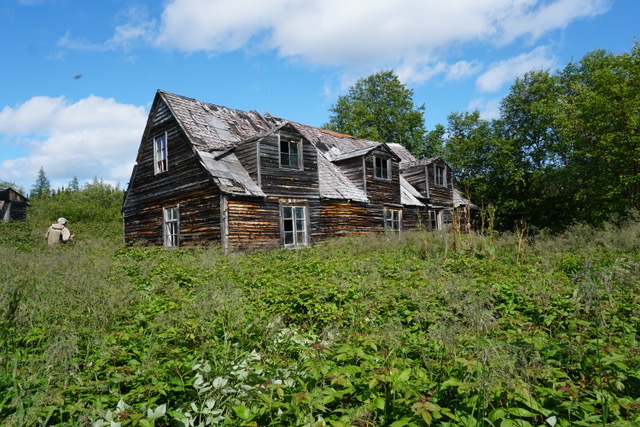
We chatted about our trip and asked a few questions about the route ahead. We were relieved to hear that the polar bears were out on the outer islands during this time of year so it was unlikely that we would meet one on our way to Hopedale. There are two buildings that instantly catch your attention in Adlatok, both from the 1860’s and both built the great-great-grandfather of the man on the porch. They said it was fine to visit them after lunch, but warned us to “watch out for a three-legged bear – we saw one as we boated in this morning.” We had lunch and made our way through the tall grasses and raspberry canes to admire the construction methods that had kept the buildings standing for such a long time. No three-legged bears here, however!
We left Adlatok and rounded the corner into a stiff headwind and waves kicking up. We scanned the far shore to decide on our crossing angle – and then spotted the three-legged bear speeding along the shore. Marian and I had contemplated putting on dry suits on shore, but we changed our minds pretty quickly. There was a line of small islands on our crossing angle so they would provide resting spots in the lee of each one and a chance to don our drysuits if necessary. We reached the far shore, and began to look for camp. We found a beach in the nook of a small point and decided we had a dandy place to call home for the night between two rocky outcrops.

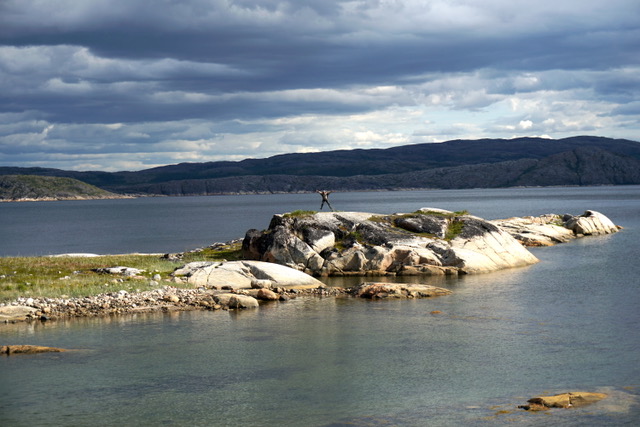
We enjoyed a tailwind on Day 11 as we made our way further and further out the bay. The terrain continued to dazzle our senses. We passed several cabins and stopped for lunch beside one, perched on a rock. A few hours later, we filled our water bags from a stream and started to look for a campsite. The shores sported cliffs with only minute beaches. We paddled on and then spotted a small island that held potential. We paddled over to the smooth rocky lump and jumped out of our boats.
Just up from the beach, a soft green carpet called out for tents. As we climbed the small slope behind it, a small black head popped up. I called out, “That’s a bear – let’s retreat!” We backed down the slope and rapidly pushed off from shore. As we rounded the corner, Darren said, “Hey, there goes the bear swimming across to the mainland.” We marvelled at its swimming speed, trying to capture it with our cameras. After it reached the far shore and turned south, we considered whether to camp on “Beary Island.” Since the bear had moved on so quickly, we decided it likely wasn’t coming back, so the island was ours. It was early afternoon and still quite hot. We enjoyed getting gear dried out, exploring the island, and setting up Mark’s wireless motion-sensing bear detection system. Testing the system, it easily detected me sneaking into camp. Later that night, however, it seemed overly sensitive as Mark jumped out of the tent twice with his shotgun to confront field mice.
We set off on Day 12 with another tailwind (three times lucky!) and set a bearing for a rocky headland. With that crossing done, we rounded a point that had rocks scattered about like pepper on a fancy meal. Looking down, we noticed that the shallows were filled with mussels. We harvested lunch from the comfort of our boats and cooked up a delicious scoff on a nearby beach. The afternoon temperature was very hot, so we sought out a few snow patches (leftover from the previous winter) and cooled off near them. Mark scoped out a likely campsite on the map that would likely be a good spot to take a layover. We wanted to be near enough to Hopedale to get there regardless of the weather, at a place with fresh water and good hiking.
When we arrived, Mark’s spot met all of the criteria. We camped by a lake that drained into the sea via a small creek and was surrounded by rocky hills. The campsite had a wooden tent frame apparently used in winter by folks from Hopedale. It provided a perfect host for our bug house, with a lovely view out the bay.
We spent Day 13 (Tuesday) hiking to the tops of the nearby hills, both to enjoy the views and to beat the heat. We were lucky to hit the only sunny days that Hopedale had seen all summer. Our windy perch proved excellent, and we spent much of the day looking out to the Labrador Sea for the ferry that should have been coming into Hopedale that day on its Northern swing to Nain. Mark texted Linda to get the ferry schedule, and she replied with, “The ferry sails south on 9:00 am Thursday, you must go to Hopedale tomorrow. Don’t miss the ferry!” We had a confirmed booking for 5:00 pm Thursday sailing, but the schedule had changed to leaving eight hours early with no notification. With this new information as well as an updated weather forecast, we updated our plan for paddling to Hopedale and catching the ferry.
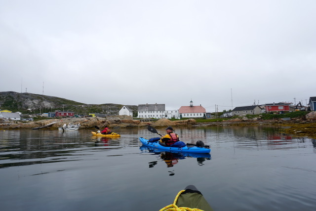
To beat a falling tide and a growing wind, we were up early on Wednesday morning to pack and make our way around three big points. We woke to drizzle and fog and set out using the coast as our handrail. A few hours later, we paddled into Hopedale and toured the village from the water from one end to the other. We paddled over to the ferry dock and found a place to land. We needed to turn in our canoes and cargo before the end of the day. We’d hoped to stay in the hotel but heard it was full. We unpacked our boats and moved them to a secure location, leaving out tents and sleeping bags to hand carry onto the ferry the next morning. We let the hotel restaurant cook for us, enjoying both lunch and dinner. Once all of our work was done, we walked around Hopedale, visiting both the old mission building and local store.
The next morning, we caught the ferry and settled into our new boat for the 36-hour journey to Goose Bay. The boat made stops in Postville, Makkovik, and Rigolet, and we were able to walk around each village as the ferry unloaded cargo. After a short sleep in Goose Bay, we all piled into Mark’s truck for the two-day jaunt back to St. John’s via the Labrador and Trans-Canada Highways. Both the ferry ride and long drive provided wonderful opportunities to reflect on the excellent trip we’d shared. Our trip plan had changed dramatically from when we first met in January eight months earlier (different group, different river), but by working together as a team from start to finish, we’ve experienced a new collection of stories to tell (and relive) of shared challenges, expedition meals, and dramatic landscapes. Journeying together in remote and wild places requires us to depend on each other in deeper, and often unspoken ways–learning and knowing each other’s strengths and places of struggle–bringing out the best of ourselves as we navigate the wild water, the stormy skies, and encounters with wild animals.
")


Pingback: River with Two Names Expedition Photo Gallery | TA Loeffler's Adventures that Move
Pingback: WaterLily Turbine on the River with Two Names | TA Loeffler's Adventures that Move
Pingback: World Premiere: OMD and the School of Drag | TA Loeffler's Adventures that Move