With the spike in COVID-19 cases here in my region after months of doing fantastic keeping the virus at bay, I was thinking about our collective grief, sadness, anger, and sense of overwhelm at feeling like we are back at the beginning of the pandemic again. We know the tough grind of social isolation, lockdown, and living in fear of the moment we now find ourselves in. Like so many other moments, my mind turns to the lessons that high places have taught me about hanging in in tough places, keeping going when I am spent and exhausted, and living with a fear of impending harm from the dangerous conditions I am climbing in. I remembered three blog posts in particular and I have reposted them below to make them easier to find and read. Two were written while Marian and I were on our 90-day Paddling North Expedition where we canoed from Jasper, Alberta to Tuktoyaktuk, NWT and one was last March when we first had to retreat from our regular lives into isolation, remote learning, and curb-side.
All three posts draw on lessons learned on expeditions on Everest and Aconcagua (highest peak in South America) and today I had the thought that living with/through the COVID-19 pandemic is somewhat like climbing Everest (though this “expedition” is significantly longer than climbing Everest.) I’m going to do a remix on my previous blog posts to highlight some of the similarities to remind myself to hang in-that the summit push is always longer than we want it to be.
1. Both are Everest and COVID-19 are long expeditions. Everest is usually a 50-60 day expedition and this one is almost a year!
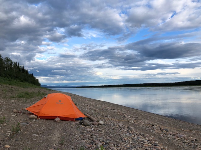
2. Both involve living in a bubble (tent) for most of the expedition with your bubble being key to your safety and securing. A thin nylon cocoon, that is both surprisingly resilient and remarkably fragile. A sudden intense gust can break a pole which can rip a hole in seconds if your bubble is not properly secured ( or sometimes even if it is).
3. Both involve leaving positions of relative security to move through the landscape, exposed to intense elements of weather, topography, and potential exposure to the virus. These intense environments can change from awe-inspiring and easy to terrifying and life-threatening in the time it takes to consult your map.
4. Both involve the ability to stay focused and motivated for the long haul. Everest requires that you traverse lower camps repeatedly as you acclimatize to the altitude and COVID-19 requires adjust swiftly to changes in caseload, regulations, and routines. You must ride waves of motivational doldrums when the virus forces you to sit still and progress stalls for several days in a row. You must be able to stay positive and committed to your expedition goals on both easy and difficult days.
5. Both involve spending time away from friends, family, and support networks in remote, self-isolation, or quarantine, settings. Current communications technology helps cross this divide but it can be time-consuming and sometimes distracting, to keep all electronics working to enable such contact across the miles.
6. Both involve “Stay or Go” decisions at regular intervals where you need to assess viral exposure conditions as well as health and psychological factors in deciding whether to push on or stay put.
7. Both (for me anyway) are spiritual quests that connect me to my core to the (inner) landscapes I am traversing, regularly humble me to my core, and provide embodied lessons of spiritual teachings around every corner and crevasse.
8. Both require specialized clothing to protect you from the cold (and in this case, a very nasty bug.)
9. It’s hardest to push to the end/summit/goal through the haze of acquired fatigue. This fatigue can be intensely demotivating.
10. Just when you are most tired and wore out, the biggest, longest, hardest, most technical, and most committing challenges come.
11. Many folks around you, some of whom you’ve climbed or paddled with, will opt not to climb higher or paddle further or bubble up correctly. This can also weigh heavily on your mind and be demotivating.
12. You will often face the most wind, most cold, and challenging weather nearest the summit (and the most virus too).
13. As you climb, the altitude gets higher and hypoxia (low oxygen) makes you slower. You much work harder for each step in the upward direction.
14. As your summit bid draws near, doubt builds as well. You question your ability to pull it off and if you even still want to pull it off. Then you remember why you took on this mountain in the first place and make the decision to go for it, forsaking comfort, ease, and slacking off for one last big push to the top.
15. It’s much easier to go down than to keep climbing up but the views from the summit are life-changing.
17. The summit is obtained by taking one step after another step for hours and days. Even when you think you don’t have another step left in you.
18. The summit is only halfway. It’s important to continue to have the big picture, keep an eye to risk management, and never let the goal be worth more than returning safely to climb again.
So friends, we are still on the COVID-19 expedition. We, like climbers crossing a crevassed ice field, are both alone and together. We are physically distancing/socially isolating in our home versions of a cozy nylon cocoon. We may be there on our own. With one or two others. Or a bigger expedition team. We are also part of a much bigger team. A team that asks and requires that we supplant self for the collective good-that asks that we take the direction of the expedition leaders. We are all on an expedition team that is climbing a huge mountain. We know it is big. We know the climb is long. We don’t know how long. But we must climb it both alone (doing our part, staying home, working with our minds and emotions) and together (looking out for teammates who might need you to carry their pack or fix their blisters or give them words of inspiration and encouragement). We can’t eat all of the M & M’s during the first week-we have to save our favourite snacks for when we really need a boost. We need to get our tent mates lots of slack-especially if you’re not used to sharing a tent for so much time. We need to step up and do more than our share of the chores. Before we’re asked. We can create both connection and space in our tent. We need mountains of compassion for ourselves and for others. On this expedition, I’m loading my backpack full of “The Benefit of the Doubt” so I can give it away freely. Kindness, compassion, and a huge dose of common sense will make this expedition easier.
The biggest thing that climbing expeditions have taught me is “Never look up at the entire mountain.” It will seem too hard, too far, too expensive, too scary, too cold, or too all of the above. Look instead at your feet. Look at your climbing boots. Look to taking one step. Just one step. Towards the summit. Towards safety. Towards whichever the team needs to go. Then take another. And another. If you do look up and get a glance of the long journey ahead with its false summits, hopes, and fears, turn your gaze down once again to the footsteps you are making, one step at a time, one hour at a time, one day at a time. For if we keep taking the steps required of us by the mountain, we will make a path by walking it.
Hold Fast Newfoundland and Labrador. Our expedition summit push just got longer but we got this! Thanks to Dr. Janice Fitzgerald and her team and all frontline workers who are working so hard for us. Let’s do our part!
How #PaddlingNorth is Like Climbing Everest

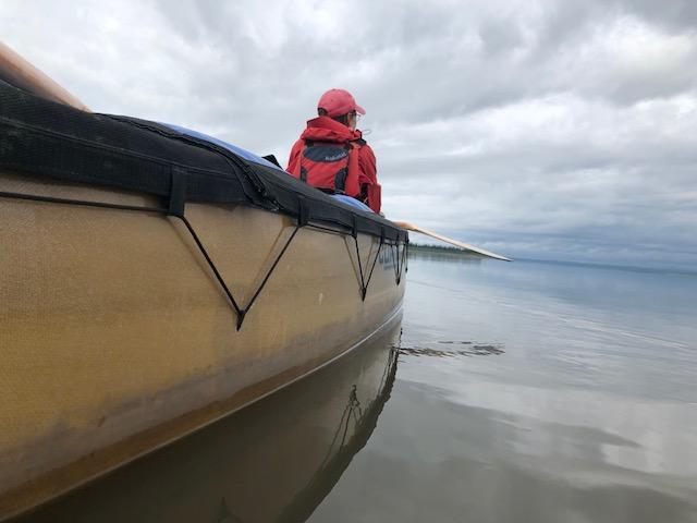
As I was paddling last evening against a potentially building wind, I thought about how this expedition shares similarities with climbing Everest. I’ve made three attempts at climbing Everest and reached a high point of 7600 metres in 2010. I’m currently on day 58 of this expedition (paddling 3000 km between Jasper, Alberta and Tuktoyaktuk, Northwest Territories) in my tent being blasted by wind and baked by the sun and am flooded with memories of similar times on the flanks of Everest.

So you ask, “how are the two expeditions alike?”
1. Both are long expeditions. Everest is usually a 50-60 day expedition and this one is 90 days.
2. Both involve living in a tent for most of the expedition with your tent being key to your safety and securing. A thin nylon cocoon, that is both surprisingly resilient and remarkably fragile. A sudden intense gust can break a pole which can rip a hole in seconds if your tent is not properly secured ( or sometimes even if it is).
3. Both involve leaving positions of relative security to move through the landscape, exposed to intense elements of weather, topography, and water/ice. These intense environments can change from awe-inspiring and easy to terrifying and life-threatening in the time it takes to consult your map.
4. Both involve moving through the above in the dark, at dusk or dawn, with little sleep. This makes such movement more challenging than moving in the daytime but also more special and rewarding as you are treated to displays of stars, planets, and the wicked dance of the sun setting or rising.

5. Both involve the ability to stay focused and motivated for the long haul. Everest requires that you traverse lower camps repeatedly as you acclimatize to the altitude and paddling North requires that you paddle a marathon most days and then set up camp. You must ride waves of motivational doldrums when weather forces you to sit still and progress stalls for several days in a row. You must be able to stay positive and committed to your expedition goals on both easy and difficult days.
6. Both involve spending time away from friends, family, and support networks in remote locations where rescue is very expensive and never guaranteed. Current communications technology helps cross this divide but it can be time-consuming and sometimes distracting, to keep all electronics working to enable such contact across the miles.
7. Both involve “Stay or Go” decisions at regular intervals where you need to assess weather and environmental conditions as well as health and psychological factors in deciding whether to push on or stay put.
8. Both are deeply rewarding, intensely challenging, and ask you to be the best adventurer/climber/paddler/teammate you can be.
9. Both (for me anyway) are spiritual quests that connect me to my core to the landscapes I am traversing, regularly humble me to my core, and provide embodied lessons of spiritual teachings around every corner and crevasse.
10. Both involve long months of planning and preparation that are indeed, part of the expedition.
OK. Gotta stop for now since the wind is gusting more strongly and I want to add more guy lines to our cocoon. I love having you along on this (and all my expeditions). Sharing the experiences helps me understand them more deeply.

Posted on August 6, 2018 by TA Loeffler

A few weeks ago, I wrote a post about the similarities between this expedition and climbing Everest. You can find that post here: How #PaddlingNorth is Like Climbing Everest https://taloeffler.com/2018/07/13/how-paddlingnorth-is-like-climbing-everest/ This is part two.

Marian and I reached Inuvik last night about 1:30 am after two days of long paddles with little current to assist us. We decided to push into Inuvik because we knew we would likely be winded off today and we wanted to use it for planning and decision making. We were winded off and we did use the day to make our plans.

Some may remember that Marian and I were up here in March doing a dog sledding program (as well as scouting for this expedition). We had a fabulous learning time and even paid a visit to Tuktoyaktuk because the all weather road had opened to the community. We also went to Tuk in case we didn’t get to paddle there on this expedition because we were stopped by weather, injury, or fatigue.

Marian and I had totally been putting off the decision about whether or not we would paddle to Tuk until we reached Inuvik. We’d originally thought it would take us four days to get here but, because we pushed, it only took two and thus today was our decision day. Today reminded me of summit bids on Everest (and all mountains really.). Thus the part two…how this “summit push” to Tuktoyaktuk is similar to one on Everest.

1. Both require specialized clothing to protect you from the cold (and in this case, the bugs. )
2. It’s hardest to push to the end/summit/goal through the haze of acquired fatigue. This fatigue can be intensely demotivating.
3. Just when you are most tired and wore out, the biggest, longest, hardest, most technical, and most committing challenges come.
4. Many folks around you, some of whom you’ve climbed or paddled with, will opt not to climb higher or paddle further and will head home. This can also weigh heavily on your mind and be demotivating.
5. You will often face the most wind, most cold, and challenging weather nearest the top/ocean. (Most bugs too).
6. As you climb, the altitude gets higher and hypoxia (low oxygen) makes you slower. As you paddle a river delta, the current dissipates and you much work harder for each kilometre.
7. As your summit bid draws near, doubt builds as well. You question your ability to pull it off and if you even still want to pull it off. Then you remember why you took on this mountain/river in the first place and make the decision to go for it, forsaking comfort, ease, and slacking off for one last big push to the top/end.
8. It’s much easier to go down than to keep climbing up but the views from the summit are life-changing.
9. The summit is obtained by taking one step after another step for hours and days or by taking paddle stroke by paddle stroke. Even when you think you don’t have another step or paddle stroke left in you.
10. The summit is only halfway. It’s important to continue to have the big picture, keep an eye to risk management, and never let the goal be worth more than returning safely to climb and paddle again.

We are off on the final phase of Paddling North, our summit push, tomorrow. We are not sure how long it will take-that will depend on weather and paddling conditions…likely in the vicinity of a week or so. We’ll continue to share audio posts and SPOT posts so you can hear witness to our daily progress making our way past the 3000 km mark, past 69 degrees North, and our arrival in Tuktoyaktuk. As always, we appreciate you cheering us on. We plan to continue our conservative paddling decision making and risk management style that has brought us 2880 kilometres safely thus far!
To the summit and safe return!

Posted on March 26, 2020 by TA Loeffler

It feels like I’m on an expedition and I don’t know when this expedition will end. That’s new, because most of my expeditions have an end date when the float plane comes, when the climbing season ends due to monsoon, or when we have to catch a ferry. We often have to rush to get an objective met (peak climbed or river paddled) but then slow to a crawl and wait in sight of the end so we can get there (the classic “hurry-up and wait). Out on expeditions, there are always the uncertainties of health, motivation, crevasses, sea state, wave height, wind, snow, sun–all of which can propel us forward or stop us in our tracks.
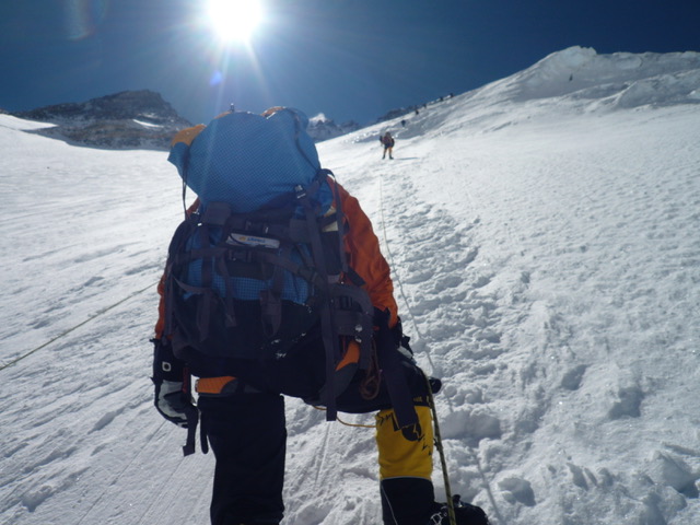
I remember being pinned to a tent for five days of Aconcagua because of high winds at Camp One. We had made the team decision that we would travel light so I only had five sheets of paper and a pencil for entertainment. No book. No cards. No I-Phone. Just the wind shaking the tent violently day and night. Most days we wondered if the tents and us would survive to climb up or down. Sleep was near impossible as was cooking and eating. Managing getting out of the tent to attend nature’s call was both a huge chore and scary because you weren’t sure where the wind would take you. There were five different climbing expeditions stranded at Camp One when the storm began.
Three days in, there was a brief lull in the morning. What do we do when faced with a diminishing time schedule and 130 kilometer per hour winds? We did as the Chinese proverb suggests, “We have little time so we must proceed very slowly.” We were already at Camp One much longer than we wanted to be…the weather forecast wasn’t great but every team except ours moved up. Nearing the end of their patience, they rushed up. A delicate study in leadership, peer pressure, and restraint ensued and resulted in much logicisticating, gnashing, and impatience as our leader decided we would sit for our third day in a row. From his past experience on the mountain, he said, “We need to stay put.” And so we did.
I made up more Sudoku puzzles on my now well-used paper, solved them erased them, and started over. Again and again. The puzzles gave my mind something to focus on besides the wind. Besides my fear. Besides my annoyance at my two other tent mates. We’d lived shoulder to shoulder in a tent the size of a single mattress for days. That night as the wind imitated runaway freight train after runaway freight train, our thoughts drifted to the higher camps and we worried how the others were surviving such a vicious night. The next day we sat once more. The following day, the mountain bled teams down its flanks. Battered humans limped down from higher camps and fled the mountain in disgust after being hammered through two nights by the unrelenting winds. The storm was much worse at Camp Two and it beat up both their bodies and their spirits. Their expeditions were over. We sat, unscathed, and able to climb higher the next day when the weather finally broke. Patience, in the impossible face of thinning time, is indeed a virtue.

Over the course of the expedition, I came to see my tent as a cocoon. A bright orange nylon cocoon. A safe place to crawl into, to rest, to sleep, to recharge, to escape the pounding of the elements. I marvelled at how the thin walls offered such protection and respite and gave thanks for every gust they withstood. Inside its walls, the temperature would rise to a bearable warmth, layers could be shed, and thoughts could be thought. The thin orange wall held the line between life and death, comfort and pain, sleep and exhaustion.
Altitude is the ultimate humbler. It stripes away speed and replaces it with a necessity for slow movement. Any rapid action results in severe panting or lightheadedness. Slow. Steady. Rhythmic breathing. One step, one breath. Even after days. Even after coming down from high. Slow is the way. The only way. It’s hard to imagine at sea level just how slowly we move at altitude. The memory is short. Try it sometime. Breathe. Take a step. Breathe again. Take another step. Imagine a slow-moving sloth in the zoo. Move like him. Deliberate. Overcome the lack of oxygen with deliberate movement and deliberate thought. It’s like being drunk for weeks without the buzz just the intense need for mindfulness and focus.
When venturing into environs where the body isn’t designed to go, the mind needs to make up the difference by being even stronger. You must will yourself to eat. You must will yourself to drink. And drink. And drink. One litre for every 1000 meters of elevation…so near the top we are drinking close to two gallons each per day. What goes in must come out and sleep is always interrupted by both the altitude and the need to “dehydrate.” The 12 hour nights become a series of cat naps interrupted by high-risk adventures with the pee bottle. Indeed, a urinary “incident” almost costs me my summit attempt by dampening my only set of long underwear but I manage to get them dried in time. The smallest of details can stand in the way of the summit.
Hardship. That’s life at altitude. Vision. Views from high places. Stark understanding. Rising above. Seeing nothing higher. Seeing in new ways. This is what makes the hardship both bearable and worth it. Seeing and then coming down having seen. Pushing through. Giving up comfort. Working with my mind. Finding small pockets of fun and absurdity and laughter and connection. Seeing the morning light dance circles. Watching the evening sun drain from the hills. Sinking into a rich rhythm of physical exertion. Learning the lessons that come from days and days of outdoor living, the whispers of the stars, and the drone of the wind. All are my teachers and the mountains exact deep lessons.
Rocks. Aconcagua is a mountain of many rocks. Small rocks. Big rocks. Brown rocks. Dusty rocks. My new boots are beaten to a pulp, they prefer snow but I was glad to get to know them. The Stone Sentinel is an apt name. Talus. Scree. Gravel. Everywhere. Erosion lives. Both externally and within. New layers are constantly revealed. The mountain falls from the top. It’s not the prettiest mountain but there is rugged beauty in its failing flanks like the wisdom bore witness by wrinkles in the face of a Navaho elder. There is solidity in standing when all else is falling.
Groceries. Don’t run out of these. We talk of food being our gasoline and water being our oil. We need both to run. The trick is when it is too cold to stop for long. Breaks must be rushed to keep blood in toes and fingers. Eating, drinking, peeing, and sunscreen must be squished into mere minutes of inactivity. Keep the engine revved or motivation wanes.
The Windy Traverse. Cold. Windy. In the shade. Early morning. Rising gently then much more abruptly. Wonder if I’ve got the climb in me. Have a discussion with myself about the potential of stopping. Of turning around. Of failing in one definition. Realizing it would be OK to stop. Folks would understand. Then thinking of all of the children I’ve talked to over the past year, remember my friend Deb who got through the rigorous and dangerous journey of chemotherapy and realize I can’t stop just yet. We take a break. I feed. I water. My steps become lighter and easier. I was out of groceries. Decide to never make a “go down” decision without oil and gasoline. This lesson has served me well.
Alone. I alone must take the steps up the mountain. It is my will that makes the boots rise to meet the challenge. It is my heart that hangs in…in the face of doubt, in the face huge avalanches of doubt, in the cold dark sleepless hours of a high altitude night…but it is the love and care and support of those who have gathered me in their collective arms from afar that keeps me stepping. I’ve come to count on the support circle that collects me in, celebrates with me, commiserates with me, and fills me with inspiration when my tank is empty. Alone and together. That’s what we are in this life and on the mountains and while at sea and at home. Both alone and together. Thank you for being part of my together. You helped me up Aconcagua and many other mountains.
The afternoon we moved to high camp, I really doubted whether I would even have a chance to try for the summit. After setting up camp by moving lots of rocks to make the tents super solid, a big jackhammer set up residence in my skull. A pounding headache battered my brain with the tenacity of a two-year-old who wants a treat. Waves of anticipated disappointment washed over my being and I slumped into the tent with my water bottle. I sucked back quart after quart of three-week outdoor cooking infused snowmelt and began to breathe.
Water and air were the only hopes of mitigating the jagged throb that was now my existence. I lay in my sleeping bag drawing in deep breath after deep breath. I did the Buddhist practice of Tonglen whereby I drew in my pain and the pain of all others with altitude headaches with every breath and then sent out relief with every exhalation. In. Out. Hope. In. Out. Can’t ascend with a headache. Breathe. Drink. Hope. In. Out. In. Out. Hope. In. Out. Can’t ascend with a headache. Breathe. Drink. Hope. In. Out. As you already know, it eventually worked. The headache eased and I was able to give the summit a go.

Summit. Can go no higher. Smile. Big smile. Amazed that I am standing at the top. As I flew into St. John’s after that climb, the pilot announced that we just passed through 23,000 feet. I look out the window amazed that I stood at that same elevation just days before. Imagine. Standing where planes fly. And imaginations run wild. And dreams come true.
So friends, we are all on an expedition. We, like climbers crossing a crevassed ice field, are both alone and together. We are physically distancing/socially isolating in our home versions of a cozy nylon cocoon. We may be there on our own. With one or two others. Or a bigger expedition team. We are are also part of a much bigger team. A team that asks and requires that we supplant self for the collective good-that asks that we take the direction of the expedition leaders. We are all on an expedition team that is climbing a huge mountain. We know it is big. We know the climb is long. We don’t know how long. But we must climb it both alone (doing our part, staying home, working with our minds and emotions) and together (looking out for teammates who might need you to carry their pack or fix their blisters or give them words of inspiration and encouragement). We can’t eat all of the M & M’s during the first week-we have to save our favourite snacks for when we really need a boost. We need to get our tent mates lots of slack-especially if you’re not used to sharing a tent for so much time. We need to step up and do more than our share of the chores. Before we’re asked. We can create both connection and space in our tent. We need mountains of compassion for ourselves and for others. On this expedition, I’m loading my backpack full of “The Benefit of the Doubt” so I can give it away freely. Kindness, compassion, and a huge dose of common sense will make this expedition easier.
The biggest thing that climbing expeditions have taught me is “Never look up at the entire mountain.” It will seem too hard, too far, too expensive, too scary, too cold, or too all of the above. Look instead at your feet. Look at your climbing boots. Look to taking one step. Just one step. Towards the summit. Towards safety. Towards whichever the team needs to go. Then take another. And another. If you do look up and get a glance of the long journey ahead with its false summits, hopes, and fears, turn your gaze down once again to the footsteps you are making, one step at a time, one hour at a time, one day at a time. For if we keep taking the steps required of us by the mountain, we will make a path by walking it.

If you’d like to read a few more posts about learnings from other expeditions, here’s a good place to start.


")


